Most holidays I poke fun at my wife for making hosting guests harder than it needs to be. She'll demand to do things "the right way", which usually means cooking gigantic dishes from scratch. Not quite growing your own wheat in the backyard for a season and milling it to make your own homemade flour, but it's usually close to that; we've grown our own pumpkins in the garden for pumpkin pies. There were many years of trying to make pumpernickel rolls from scratch. We discovered a nearby Amish market last year and holiday cooking has never been better. The Amish are spectacular bakers.
So it is with some chagrin I must to confess how I became distracted when I sat down to make a map for Erda. Somehow "sketching an area map for my new campaign" devolved into "Gee, I should learn various fractal mapping softwares and create a full fractal world, with climate, wind patterns, ocean currents, and naturalistic erosion". So that's where I've been hiding out a couple of weeks.
I've owned a piece of fractal mapping software for a while, "Fractal Terrains" (FT3) that's part of the Campaign Cartographer suite (CC3). I hadn't used Campaign Cartographer in a few years, so I needed to dust it off and re-acclimate - it's a powerful CAD-style drawing platform, but the learning curve is real. My mapping journey took me into fractal world building, leveraging a free fractal tool called "Wilbur" to apply naturalistic erosion and generating rivers on a fractal world, and ultimately importing maps back into CC3 for finishing. (There are tutorials out there, and the various online cartographer groups with the pros are filled with helpful folks, so it's not like I could've done this without the wisdom of actual experts).
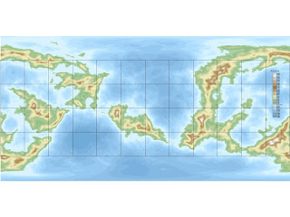
Onward to the maps. First up, here's the actual fractal world itself after development in Fractal Terrains, erosion in Wilbur, and then brought back into Fractal Terrains to add rivers:
 |
| Erda in Fractal Terrains |
 |
| Erda Globe View |
 |
| Work in progress - the Fractal Map in Campaign Cartographer |
 |
| Northwest Erda |
 |
| Erda - The Known World |
Heading east is the sprawling empire of Caronia. I've had it titled this way in one of my notebooks since last year - but I may need to rename it depending on what happens with this scary carona virus! As it stands now, Caronia is a sprawling homage to Charlemagne and the Holy Roman Empire. The Great March is a military zone manned by border nobles of Caronia and mercenaries of The Folk, the barbarians and woodmen of the southeastern vales (including Grossval).
The southern coast of the continent is home to the principalities of Aurum and the theocracy of Topaz, inheritors to civilization after old Valorum fell in the magical apocalypse that reconnected the magic worlds and allowed fresh invasions from Jotunheim and Niflheim, creating the current dark age. Beyond Valorum (and off the map to the south) the lands turn dry and desert and we find the ruins of antiquity.
Above the whale road are Scandia and Greatland, the two nordic realms of the setting. Invasions of giants and dragons from the west have made the northern cultures tough and fatalistic in the face of ever colder winters and darker nights. A culture of "vikings" has developed, with sea-faring reavers attacking softer targets from Aurum all the way along the whale road to Caronia. North of the Calden Sea is Thule, where I'll place the Black City when I work on a 5E update to that one. So far my kids have been pushing me to build out Harrowdale rather than revisiting the Black City first, but we'll see what the rest of the player group says.
Anyway, this what I've been doing instead of writing blog posts for a week or two. I've been on a map-bender!

No comments:
Post a Comment